Fine ArtVintageFootageSubscriptionBoardsFree ResearchPricing
  • Fine Art
  • Vintage
  • Footage
  • Subscription
  • Boards
  • Free Research
  • Pricing

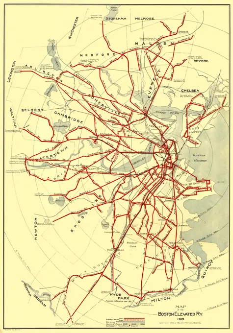
Boston Historical Maps

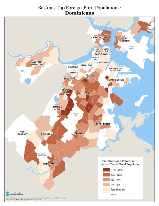
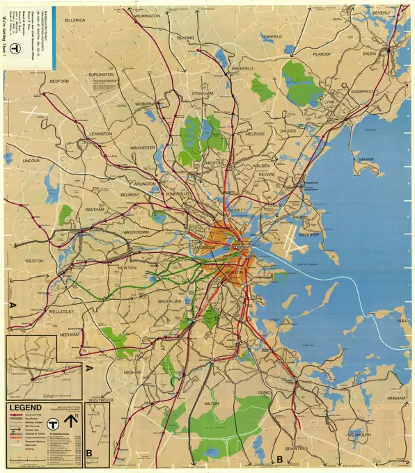
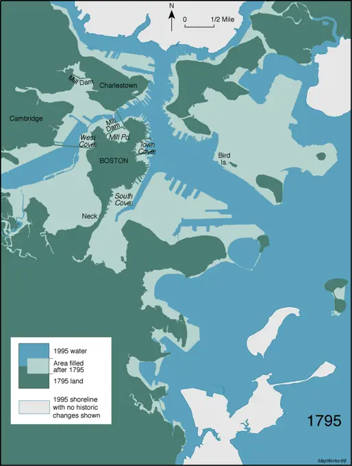
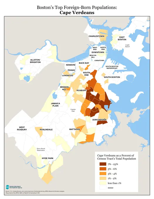
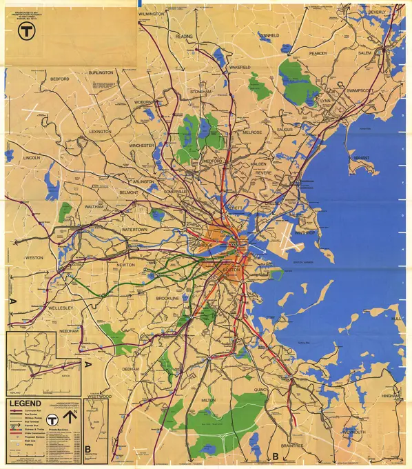
Maps illustrating Boston's historical shoreline and transportation systems, highlighting significant geographical changes over the centuries.

Metropolitan Transit Authority system route map , Local transit, Massachusetts, Boston, Maps, Boston Mass., Maps, Metropolitan Transit Authority Boston, Mass. Norman B. Leventhal Map Center Collection
55 assets in this story
6145-43861056
Tax parcels that would have been underwater in 1630 , Fills Earthwork, Massachusetts, Boston, Maps, Real property, Massachusetts, Boston, Maps, Boston Mass., Historical geography, Maps Norman B. Leventhal Map Center Collection
6145-51929780
Tax parcels that would have been underwater in 1630. Shows 1630 shoreline and indicates current tax parcels that would have been fully or partly underwater in 1630.... , Massachusetts  , Suffolk  ,county   , Boston
6145-54268815
Boston shoreline 1880. Cartography by Herb Heidt and Eliza McClennen of MapWorks for Mapping Boston edited by Alex Krieger and David Cobb with Amy Turner. Cambridge, MA : MIT Press, 1999.... , Massachusetts  , Suffolk  ,county   , Boston
6145-55167682
T system map : 1978-1979. Includes text and diagram of downtown mall. Insets: A. To Framingham-Natick -- B. To Randolph-Avon. Includes list of private bus lines. On verso: Text -- Schedules subway, bus, commuter rail -- Points of interest -- T rapid transit lines -- T commuter rail lines -- Central Boston.... , Massachusetts  , Suffolk  ,county   , Boston
6145-51395500
Metropolitan Boston transportation map : subway, bus, rail , Local transit, Massachusetts, Boston, Maps, Subways, Massachusetts, Boston, Maps, Bus rapid transit, Massachusetts, Boston, Maps, Boston Mass., Maps, Massachusetts Bay Transportation Authority Norman B. Leventhal Map Center Collection
6145-51395498
Metropolitan Boston transportation map : subway, bus, rail , Local transit, Massachusetts, Boston, Maps, Subways, Massachusetts, Boston, Maps, Bus rapid transit, Massachusetts, Boston, Maps, Boston Mass., Maps, Massachusetts Bay Transportation Authority Norman B. Leventhal Map Center Collection
6145-43860550
Boston shoreline 1916 , Boston Mass., Historical geography, Maps Norman B. Leventhal Map Center Collection
6145-51395510
Metropolitan Transit Authority system route map , Local transit, Massachusetts, Boston, Maps, Boston Mass., Maps, Metropolitan Transit Authority Boston, Mass. Norman B. Leventhal Map Center Collection
6145-43860569
Boston shoreline 1995 , Boston Mass., Historical geography, Maps Norman B. Leventhal Map Center Collection
6145-48640893
Boston's top foreign-born populations : Vietnamese , Boston Mass., Maps, Immigrants, Massachusetts, Boston, Maps, Vietnamese, Massachusetts, Boston, Maps Norman B. Leventhal Map Center Collection
6145-43860576
Boston shoreline composite , Boston Mass., Historical geography, Maps Norman B. Leventhal Map Center Collection
6145-51929751
Boston's top foreign-born populations : Dominicans. "Source: U.S. Census Bureau, 2011-2015 American Community Survey, BPDA Research Division Analysis.". According to the U.S Census Bureau, the patterns of immigration to Boston during the first decades of the 21st century are much different than those of the first decades of the 20th century. Currently the majority of immigrant groups come from the Caribbean (28.8%) and Asia (27.8%), while those coming over 100 years ago came mainly from Europe (Ireland, Italy, and Russia)... , Massachusetts  , Suffolk  ,county   , Boston
6145-50554476
Metropolitan Boston transportation map : subway, bus, rail , Local transit, Massachusetts, Boston, Maps, Subways, Massachusetts, Boston, Maps, Bus rapid transit, Massachusetts, Boston, Maps, Boston Mass., Maps, Massachusetts Bay Transportation Authority Norman B. Leventhal Map Center Collection
6145-51929734
Boston shoreline 1795. Cartography by Herb Heidt and Eliza McClennen of MapWorks for Mapping Boston edited by Alex Krieger and David Cobb with Amy Turner. Cambridge, MA : MIT Press, 1999.... , Massachusetts  , Suffolk  ,county   , Boston
6145-55963708
Boston development program
6145-51392538
1975 general land use plan , Boston Mass., Maps, City planning, Massachusetts, Boston, Maps, Urban renewal, Massachusetts, Boston, Maps, Land use, Massachusetts, Boston, Maps
6145-43860547
Boston shoreline 1795 , Boston Mass., Historical geography, Maps Norman B. Leventhal Map Center Collection
6145-51929750
Boston's top foreign-born populations : Cape Verdeans. "Source: U.S. Census Bureau, 2011-2015 American Community Survey, BPDA Research Division Analysis.". According to the U.S Census Bureau, the patterns of immigration to Boston during the first decades of the 21st century are much different than those of the first decades of the 20th century. Currently the majority of immigrant groups come from the Caribbean (28.8%) and Asia (27.8%), while those coming over 100 years ago came mainly from Europe (Ireland, Italy, and Russia)... , Massachusetts  , Suffolk  ,county   , Boston
6145-51391618
Boston Elevated Railway system route map , Local transit, Massachusetts, Boston, Maps, Boston Mass., Maps, Boston Elevated Railway Company Norman B. Leventhal Map Center Collection
6145-51391614
Boston Elevated Railway system route map , Local transit, Massachusetts, Boston, Maps, Boston Mass., Maps, Boston Elevated Railway Company Norman B. Leventhal Map Center Collection
6145-55916412
Boston streets & neighborhoods. "Neighborhood boundaries are created base on zip code and zoning district boundaries." March 2014.. This map outlines the 26 neighborhoods in Boston by zip code and zoning district boundaries. Boston is often thought of as a collection of neighborhoods, each uniquely reflecting who lives and works there. These municipally-defined boundaries are compared to those displayed in the nearby neighborhood consensus map, which illustrates the mental maps residents create for their own neighborhoods.. Boston streets and neighborhoods. Boston streets and neighborhoods, Massachusetts  , Suffolk  ,county   , Boston
6145-50568598
Metropolitan Transit Authority system route map , Local transit, Massachusetts, Boston, Maps, Boston Mass., Maps, Metropolitan Transit Authority Boston, Mass. Norman B. Leventhal Map Center Collection
6145-54268936
Boston's diversity index, 2010 : measures of diversity : race.. Another series of maps produced by the Boston Redevelopment Authority shows different measures of diversity, including race, language, age, household income, education, and region of birth. Census tracts on each map range in color from deep orange (indicating the most diverse neighborhoods) to deep green (least diverse). By comparing these various maps, it is evident that the most diverse census tracts are located in Dorchester, Roxbury, Roslindale, East Boston, and Brighton... , Massachusetts  , Suffolk  ,county   , Boston
6145-51396572
Boston Elevated Railway system route map , Local transit, Massachusetts, Boston, Maps, Boston Mass., Maps, Boston Elevated Railway Company Norman B. Leventhal Map Center Collection
6145-51395502
Metropolitan Boston transportation map : subway, bus, rail , Local transit, Massachusetts, Boston, Maps, Subways, Massachusetts, Boston, Maps, Bus rapid transit, Massachusetts, Boston, Maps, Boston Mass., Maps, Massachusetts Bay Transportation Authority Norman B. Leventhal Map Center Collection
6145-51392249
A city of unequal risks , Boston Mass., Maps, Climatic changes, Social aspects, Massachusetts, Boston, Maps, Disasters, Social aspects, Massachusetts, Boston, Maps, Floods, Massachusetts, Boston, Maps, Urban heat island, Massachusetts, Boston, Maps, Open spaces, Massachusetts, Boston, Maps Norman B. Leventhal Map Center Collection
6145-43860765
Boston open space and supermarkets , Boston Mass., Maps, Supermarkets, Massachusetts, Boston, Maps, Open spaces, Massachusetts, Boston, Maps Norman B. Leventhal Map Center Collection
6145-43860771
Boston's top foreign-born populations : Chinese , Boston Mass., Maps, Immigrants, Massachusetts, Boston, Maps, Chinese, Massachusetts, Boston, Maps Norman B. Leventhal Map Center Collection
6145-48640888
Boston's top foreign-born populations : Chinese , Boston Mass., Maps, Immigrants, Massachusetts, Boston, Maps, Chinese, Massachusetts, Boston, Maps Norman B. Leventhal Map Center Collection
6145-48640838
Boston shoreline 1950 , Boston Mass., Historical geography, Maps Norman B. Leventhal Map Center Collection
6145-51392729
Downtown Boston , Housing, Massachusetts, Boston, Maps, Church buildings, Massachusetts, Boston, Maps, Public buildings, Massachusetts, Boston, Maps, Historic sites, Massachusetts, Boston, Maps, Hospitals, Massachusetts, Boston, Maps, Hotels, Massachusetts, Boston, Maps, Subway stations, Massachusetts, Boston, Maps, Office buildings, Massachusetts, Boston, Maps, Stores, retail, Massachusetts, Boston, Maps, Open spaces, Massachusetts, Boston, Maps, Parking garages, Massachusetts, Boston, Maps, Piers, Massachusetts, Boston, Maps, Ferry terminals, Massachusetts, Boston, Maps, Boston Mass., Maps
6145-43860770
Boston's top foreign-born populations : Cape Verdeans , Boston Mass., Maps, Immigrants, Massachusetts, Boston, Maps, Cape Verdeans, Massachusetts, Boston, Maps Norman B. Leventhal Map Center Collection
6145-50561193
Downtown Boston , Housing, Massachusetts, Boston, Maps, Church buildings, Massachusetts, Boston, Maps, Public buildings, Massachusetts, Boston, Maps, Historic sites, Massachusetts, Boston, Maps, Hospitals, Massachusetts, Boston, Maps, Hotels, Massachusetts, Boston, Maps, Subway stations, Massachusetts, Boston, Maps, Office buildings, Massachusetts, Boston, Maps, Stores, retail, Massachusetts, Boston, Maps, Open spaces, Massachusetts, Boston, Maps, Parking garages, Massachusetts, Boston, Maps, Piers, Massachusetts, Boston, Maps, Ferry terminals, Massachusetts, Boston, Maps, Boston Mass., Maps
6145-50532983
Boston's neighborhoods by percentage of foreign-born (by census tract) , Boston Mass., Maps, Immigrants, Massachusetts, Boston, Maps Norman B. Leventhal Map Center Collection
6145-48718699
Boston Elevated Railway system map , Local transit, Massachusetts, Boston, Maps, Boston Mass., Maps, Boston Elevated Railway Company Norman B. Leventhal Map Center Collection
6145-51395506
Metropolitan Transit Authority system route map , Local transit, Massachusetts, Boston, Maps, Boston Mass., Maps, Metropolitan Transit Authority Boston, Mass. Norman B. Leventhal Map Center Collection
4409-28579355
Physical and political map of Bolivia. Encapsulated Postscript File (.eps); 2480x3507.
6145-54268932
Boston's diversity index, 2010 : measures of diversity : language other than English spoken at home.. Another series of maps produced by the Boston Redevelopment Authority shows different measures of diversity, including race, language, age, household income, education, and region of birth. Census tracts on each map range in color from deep orange (indicating the most diverse neighborhoods) to deep green (least diverse). By comparing these various maps, it is evident that the most diverse census tracts are located in Dorchester, Roxbury, Roslindale, East Boston, and Brighton... , Massachusetts  , Suffolk  ,county   , Boston
6145-48640883
Boston's diversity index, 2010 : measures of diversity : household income , Boston Mass., Maps, Income, Massachusetts, Boston, Maps Norman B. Leventhal Map Center Collection
6145-51395448
Massachusetts Turnpike map : the main street of Massachusetts , Massachusetts, Maps, Roads, Massachusetts, Maps, Boston Mass., Maps, Worcester Mass., Maps, Springfield Mass., Maps Norman B. Leventhal Map Center Collection
1848-19253703
Stadtplan, 1892, Smyrna, now Izmir, Türkei, digital restaurierte Reproduktion einer Originalvorlage aus dem 19. Jahrhundert
6145-50568604
Map of the Boston Elevated Ry. 1915 , Local transit, Massachusetts, Boston, Maps, Railroads, elevated, Massachusetts, Boston, Maps, Subways, Massachusetts, Boston, Maps, Boston Mass., Maps, Boston Elevated Railway Company Norman B. Leventhal Map Center Collection
4409-28579835
Infographic-map of Central and South America. QuarkXPress (.qxp); Adobe InDesign (.indd); 4960x3188.
6145-55963674
MetroWest bicycle map, 1995
6145-51395442
Massachusetts outdoor recreation plan 1966 : public outdoor recreation areas , Recreation areas, Massachusetts, Maps, Land use, Massachusetts, Maps, Massachusetts, Maps
6145-50557008
New Jersey Turnpike showing exchanges , Tichnor Brothers Collection, postcards of the United States
6145-51395988
Commonwealth of Massachusetts U.S. congressional districts , Massachusetts, Maps, Election districts, Massachusetts, Maps, Legislators, United States
6145-52601447
Creator: Laubenstein, Ronald. Subjects: Maps; Graphics; Microsoft PowerPoint; Alaska.  . 1998 - 2011.
1899-48082183
Seville, Spain - January 20, 2023: Tile decorative map showing Toledo, Madrid, Segovia, and Guadalajara. The famous place and landmark is known in Spanish as Plaza de España
6145-54268724
Boston neighborhoods : top 10 countries of birth for foreign-born population. Includes chart showing City of Boston's top 20 countries of birth for foreign born population. "Source: U.S. Census Bureau, 2010-2015 American Community Survey.". In this unique word-map the size of the words in each neighborhood expresses the proportion of foreign-born residents in that area. For example, the large Vietnam in Dorchester indicates the relative size of the Vietnamese population within that neighborhood. An inset graph in the lower right shows the top 20 countries of birth for Bostons foreign-born population as of 2015... , Massachusetts  , Suffolk  ,county   , Boston
6145-29670135
Photo collection Government information service. Delta works, maps and models. undated
6145-54604474
Zoning map of the town of Wayland Massachusetts, 1954
6145-51992209
A map of the 13 designated Individual Assistance counties and 1 designated Public Assistance county in New York for Hurricane Sandy.. Photographs Relating to Disasters and Emergency Management Programs, Activities, and Officials
6145-51992216
Map of Long Term Recovery Group, VOAD and COAD coverage for the five boroughs of New York City in support of Hurricane Sandy recovery efforts.. Photographs Relating to Disasters and Emergency Management Programs, Activities, and Officials
6145-52274569
Trail of the Mountain Spirits Scenic Byway - Trail of the Mountain Spirits Map. This map presents a graphical view of the Trail of the Mountain Spirits, its route, major points of interest, and nearby federal lands. Location: New Mexico
PREVIOUS
of 1
NEXT
2401 S. Ervay, Suite 206
Dallas, Texas 75215
United States
Browse
CategoriesGalleriesFree Research
For Creators
License Your ContentSuperStock For StudentsFrame of Mind BlogContributor PortalNew Image SpotlightLicense AI Imagery
Resources
About UsLicensingTerms & ConditionsAPI AccessPrivacyPricing
Contact
+1 866 236 0087help@superstock.com Contact form
©2026 SuperStock. All Rights Reserved. -A
This site is protected by reCAPTCHA and Google Privacy Policy and Terms of Service apply.