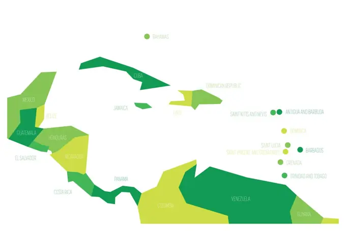
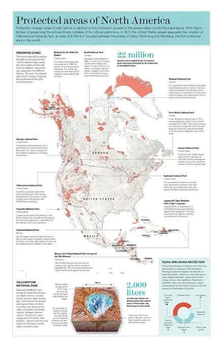
Fine ArtVintageFootageSubscriptionBoardsFree ResearchPricing
  • Fine Art
  • Vintage
  • Footage
  • Subscription
  • Boards
  • Free Research
  • Pricing

Green Geographic Maps

Illustrations of various countries depicted in green. Includes maps of Crimea, Lebanon, Papua New Guinea, Uzbekistan, and Colombia, showcasing their geographical shapes.

Green Armenia map
Green Armenia map
69 assets in this story
1525-56730633
Map of the Crimean Peninsula. Territory of Russia and Ukraine. Southern resort. Green area. Flat cartoon. Map of the Crimean Peninsula.
5507-42628786
Green Lebanon map
1848-66890043
Green Forest Map of Papua New Guinea, on white background
5507-42625868
Green Uzbekistan map
5507-41302418
Green Colombia map
5507-42628550
Green Bhutan map
5507-42628482
Green Cambodia map
5507-42628836
Green Belarus map
5507-34136690
Map of Central America and Caribbean. Simlified schematic vector map in shades of green
5507-42628581
Green Armenia map
1848-53798944
Detail of a toxic phosphogypsum waste pond in the vicinity of the town of Huelva. Aerial view. Drone shot. Huelva province, Andalusia, Spain, Europe
1848-66776377
Green Forest Map of Guatemala, on white background
5507-42624858
Green Ecuador map
1848-66780338
Green Forest Map of Kuwait, on white background
6188-67651744
Recycling in France concept, 3D rendering Recycling in France concept, 3D rendering Copyright: xZoonar.com/alexlmxx 23060967
5507-42625848
Green Kyrgyzstan map
1848-53798951
Detail of a toxic phosphogypsum waste pond in the vicinity of the town of Huelva. Aerial view. Drone shot. Huelva province, Andalusia, Spain, Europe
5507-45683804
Map of Germany devided to 13 federal states and 3 city-states - Berlin, Bremen and Hamburg, Europe. Simple flat vector map in shades of green
1848-64956651
Earth conservation metaphor, orca whale with recycle green sign in jaws
1899-82227
Relief map of the State of Delaware, United States. This image was compiled from data acquired by LANDSAT 5 & 7 satellites combined with elevation data.
5507-37990221
Map of Bangladesh with in red and green colors
1848-66605629
Mental wellness concept, Anti stress therapy Concept. Nature
5507-41328300
Green Indonesia map
6188-67689574
Recycling in the Czech Republic concept, 3D rendering recycling in the Czech Republic concept, 3D rendering copyright: xzoonar.com/alexlmxx 23160809
5507-42628190
Green South Korea map
5507-42628541
Green Bangladesh map
1397R-76228
Map of America made of grass
1525-58728455
Qatar map from green grass on a white background. Qatar map from green grass
5507-42628522
Green Thailand map
1848-66773593
Map of Botswana made of smoke, Air pollution, ecology
5507-45701611
ASEAN Economic Community, AEC, map. Grey map with green highlighted member countries, Southeast Asia. Vector illustration
1899-82254
Relief map of the State of Louisiana, United States. This image was taken in 2003 before Hurricane Katrina. It was compiled from data acquired by LANDSAT 7 satellite combined with elevation data.
1848-66776874
Map of North Carolina made of smoke, Air pollution, ecology
1848-66870527
Map of West Virginia made of smoke, Air pollution, ecology
5507-41317567
Green Central Asia
5507-34136689
Countries of Guinea Gulf - Western Africa. Simplified and schematic political map. Vector illustration in shades of green
1848-66848555
Map of Missouri made of smoke, Air pollution, ecology
5507-42628572
Green Sri Lanka map
1848-66781525
Map of Arkansas made of smoke, Air pollution, ecology
1848-66879813
Map of Guatemala made of smoke, Air pollution, ecology
5507-34136780
Political map of Africa in four shades of green with white country name labels on white background. Vector illustration
1848-66802165
Map of Montana made of smoke, Air pollution, ecology
1848-66786742
Map of Minnesota made of smoke, Air pollution, ecology
1848-66799945
Map of Delaware made of smoke, Air pollution, ecology
5507-42624221
Green Panama map
5507-42629272
Green Netherlands map
1899-82309
Relief map of the State of Oklahoma, United States. This image was compiled from data acquired by LANDSAT 5 & 7 satellites combined with elevation data.
5507-39336952
Political map of Russia and surrounding European and Asian countries. Four shades of green map with white labels on white background. Vector illustration
5507-39336950
Political map of Russia and surrounding European and Asian countries. Four shades of green map with white labels on white background. Vector illustration
1848-66780869
Map of Alabama made of smoke, Air pollution, ecology
1848-66789728
Green Forest Map of Nevada, on white background
1848-66606379
Belize flag wind farm at sunset, sustainable development, renewable energy Wind Turbines
6145-52054026
Coniferous Loopers - All States. Photographs Relating to National Forests, Resource Management Practices, Personnel, and Cultural and Economic History
1848-66786153
Map of South Carolina made of smoke, Air pollution, ecology
1848-66785504
Map of Wisconsin made of smoke, Air pollution, ecology
6145-52068500
Coast Guard Structures - Station Sabine - 26-HK-108-1. Hurricane Katrina
4409-28579823
Infographic of protected natural areas in North and Central America. QuarkXPress (.qxp); Adobe InDesign (.indd); QuarkXPress (.qxd); 3661x5669.
5507-42628783
Green Syria map
6188-56039612
Map of Oklahoma, Postal Stamp, Sustainable development, CO2 emission concept Map of Oklahoma, Postal Stamp, Sustainable development, CO2 emission concept, clipping path Copyright: xZoonar.com/AleksandarxVukicevicx 20425922
1848-66776206
Map of Kentucky made of smoke, Air pollution, ecology
1525-21071966
Michigan
6188-56039819
Map of Guyana, Postal Stamp, Sustainable development, CO2 emission concept Map of Guyana, Postal Stamp, Sustainable development, CO2 emission concept, clipping path Copyright: xZoonar.com/AleksandarxVukicevicx 20426588
6188-56039739
Map of North Carolina, Postal Stamp, Sustainable development, CO2 emission concept Map of North Carolina, Postal Stamp, Sustainable development, CO2 emission concept, clipping path Copyright: xZoonar.com/AleksandarxVukicevicx 20426153
6145-45111627
A new map created with measurements from an airborne instrument developed by NASA's Jet Propulsion Laboratory, Pasadena, California, reveals the devastating effect of California's ongoing drought on Sierra Nevada conifer forests.
1848-66875025
Map of Texas made of smoke, Air pollution, ecology
6188-56039715
Map of Arizona, Postal Stamp, Sustainable development, CO2 emission concept Map of Arizona, Postal Stamp, Sustainable development, CO2 emission concept, clipping path Copyright: xZoonar.com/AleksandarxVukicevicx 20426105
1525-23933982
An Illustration of A Horizontal Bicolor Triband of Green and White of The Federal Republic of Nigeria Flag on A Whistle, The Sport Concept and Political Symbol.
6188-56039861
Map of El Salvador, Postal Stamp, Sustainable development, CO2 emission concept Map of El Salvador, Postal Stamp, Sustainable development, CO2 emission concept, clipping path Copyright: xZoonar.com/AleksandarxVukicevicx 20426632
6145-51992190
Oso, Wash., May 20, 2014   The Oso Proud Oso Strong Flag Fundraiser sold 150 flags, 38 of which have been donated to local businesses and community members of Oso. The proceeds go to the communities affected by the SR 530 slide in Washington. So far, $750 has been raised. (Photo courtesy of Oso Proud Oso Strong Flag Fundraiser). Washington Flooding and Mudslides. Photographs Relating to Disasters and Emergency Management Programs, Activities, and Officials
PREVIOUS
of 1
NEXT
2401 S. Ervay, Suite 206
Dallas, Texas 75215
United States
Browse
CategoriesGalleriesFree Research
For Creators
License Your ContentSuperStock For StudentsFrame of Mind BlogContributor PortalNew Image SpotlightLicense AI Imagery
Resources
About UsLicensingTerms & ConditionsAPI AccessPrivacyPricing
Contact
+1 866 236 0087help@superstock.com Contact form
©2026 SuperStock. All Rights Reserved. -A
This site is protected by reCAPTCHA and Google Privacy Policy and Terms of Service apply.