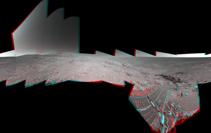
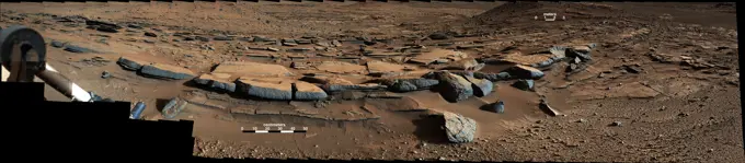
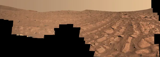
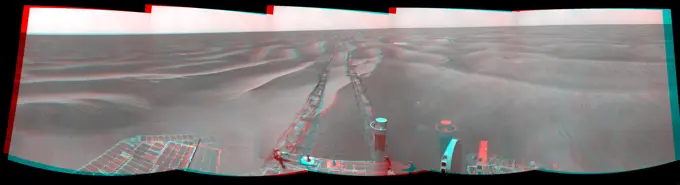
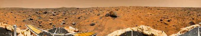
Fine ArtVintageFootageSubscriptionBoardsFree ResearchPricing
  • Fine Art
  • Vintage
  • Footage
  • Subscription
  • Boards
  • Free Research
  • Pricing

Mars Surface Exploration

High-resolution images of the Martian landscape, featuring unique geological formations such as dunes, craters, and chasms from NASA's Mars missions.

Wonders of Eos Chasma
254 assets in this story
6145-45071464
This stereo 3D scene from the Pancam on NASA's Mars Exploration Rover Opportunity looks back toward part of the west rim of Endeavour Crater that the rover drove along, heading southward, during the summer of 2014.
6145-45080329
A wheel track cuts through a windblown ripple of dusty sand in this Nov. 7, 2014, image from the Mastcam on NASA's Curiosity rover. The view spans about four feet across.
6145-44621391
Preparing for 'Lights Out' on Mars (3-D)
6145-44565107
Time Series of Jupiter's Aurora
6145-52302014
Water release disaster 1953. Air photo of Oude-Tonge with an overview of the area affected by the disaster. The road, middle, is the Molendijk with a lot of visible, mill De Korenbloem.
6145-45299053
The streak circled in the center of this image is asteroid 2020 QG, which came closer to Earth than any other nonimpacting asteroid on record. It was detected by the Zwicky Transient Facility on Sunday, Aug. 16 at 12 08 a.m. EDT (Saturday, Aug. 15 at 9 08 p.m. PDT). The wide-field camera image of the Zwicky Transient Facility, a sky-scanning survey telescope funded by the National Science Foundation and NASA, and based at Caltech's Palomar Observatory in Southern California. The image was taken six hours after the close approach, as the asteroid was heading away from Earth.
6145-44627484
This image was returned on Jan 14, 2005, by the European Space Agency's Huygens probe during its successful descent to land on Titan. This colored view, following processing to add reflection spectra data, gives a better indication of the actual color.
6145-44773015
NASA's Opportunity had driven 72.3 meters southward (237 feet) on June 10. Engineers drove the rover backward as a strategy to counteract an increase in the amount of current drawn by the drive motor of the right-front wheel. 3D glasses are necessary.
6145-44657902
NASA's Mars Exploration Rover Spirit used its panoramic camera (Pancam) to record a 360-degree vista, dubbed the 'Everest' panorama, from the top of 'Husband Hill' in early October 2005. 3D glasses are necessary to view this image.
6145-44746729
NASA's Mars Exploration Rover Opportunity combined images into this stereo, 360-degree view of the rover's surroundings on Oct. 22, 2008. Opportunity's position was about 300 meters southwest of Victoria. 3D glasses are necessary to view this image.
6145-44590771
Sojourner Latch Spring Deployed
6145-44484162
Intriguing Martian rocks surround NASA's Perseverance rover in this panorama showing an ancient river delta, made from images captured by the Mastcam-Z camera system. This 2.5-billion-pixel mosaic, which combines 1,118 individual frames, is the most detailed landscape panorama ever returned from Mars. The delta in Mars' Jezero Crater is an area where scientists surmise that, billions of years ago, a river once flowed into a lake and deposited rocks and sediments in a fan shape. Deltas are believed to be the best places on Mars to search for potential signs of ancient microbial life. Arrival at the Jezero delta has been a primary goal of the Perseverance mission since the rover landed in the crater in February 2021. The panorama shows sedimentary rocks of great interest to scientists. The Perseverance rover has abraded the surface of several rocks in this area and acquired compositional information. It also has collected rock samples that the Mars Sample Return campaign could bring back
6145-44639899
NASA's Mars Exploration Rover Spirit welcomed the beginning of 2006 on Earth by taking this striking panorama of intricately rippled sand deposits in Gusev Crater on Mars.
6145-52292963
Aerial view of a part of the area affected during the flood disaster of 1953. Note: The description of this photo is not yet complete and will be supplemented on the basis of the data available at a later stage. However, of many photos of the flood disaster 1953, the location is unknown.
6145-44706506
This image shows the workspace reachable by the scoop on the robotic arm of NASA's Phoenix Mars Lander, along with some measurements of rock sizes.
6145-44738834
Date Feb 11, 1987
6145-44935544
This frame from a movie from the Samford Valley Observatory in Brisbane, Australia, shows the progress of asteroid 2012 DA14 across the night sky as it nears its closest approach. It was taken at 12:59 UTC on Feb. 15 (7:59 a.m. EST, or 4:59 a.m. PST).
6145-44718033
S72-01713 (July 1972) --- A vertical view of the Apollo 17 landing site in the Taurus-Littrow area of the lunar nearside, with an overlay showing the Lunar Roving Vehicle traverse proposed for the second extravehicular activity. The scale at the bottom is measured in kilometers. One kilometer equals 0.6214 statute miles. The coordinates of the Apollo 17 touchdown point are 30 degrees 44 minutes 58 seconds east longitude and 20 degrees 9 minutes 50 seconds north latitude. This photograph was taken from lunar orbit on an earlier Apollo mission.
6145-45299009
Three images from the public tool AI4Mars show different kinds of Martian terrain as seen by NASA's Curiosity rover. By drawing borders around terrain features and assigning one of four labels to them, you can help train an algorithm that will automatically identify favorable and hazardous terrain for Curiosity's rover planners. You can visit AI4Mars here. All three images were generated by Curiosity's black-and-white Navigation Cameras. In the lower right corner of the first image on the left, the circle and checkerboard on is the Sample Playground, where samples of soil or pulverized rock can be trickled to study their physical properties. In the center are Curiosity's robotic arm and turret, a collection of science tools on the end of the arm.
6145-44839023
This mosaic of images from NASA's Mars Exploration Rover Opportunity shows surroundings of the rover's location following an 100.7-meter (330-foot) drive on Oct. 17, 2010. 3D glasses are necessary.
6145-44955715
The left and right eyes of the Navigation Camera (Navcam) in NASA's Curiosity Mars rover took the dozens of images combined into this 3-D scene of the rover and its surroundings.
4128-V58560347
6145-44710023
This image shows a microscopic view of fine-grained material at the tip of the Robotic Arm scoop as seen by the Robotic Arm Camera (RAC) aboard NASA's Phoenix Mars Lander on June 20, 2008, the 26th Martian day, or sol, of the mission.
6145-44483572
NASA's Curiosity Mars rover captured this image of the sulfate-bearing region and upper Mount Sharp in a dust haze on May 26, 2022, the 3,485th Martian day, or sol, of the mission. The panorama is made up of 46 individual images - captured during an especially dusty time of the Martian year - that were stitched together once the images were sent back to Earth.
1746-29000690
view from the Mastcam on NASA's Curiosity Mars rover looks southward at the Kimberley waypoint. In the foreground, multiple sandstone beds show systematic inclination to the south suggesting progressive build-out of delta sediments in that direction (toward Mount Sharp).
6145-44606780
Location of Spirit's Home
6145-44626149
Frost on Mars Rover Opportunity
6145-54676543
Perseverance's Mastcam-Z Views Rockytop. NASA's Perseverance Mars rover used its Mastcam-Z camera to capture this rocky hilltop nicknamed Rockytop on July 24, 2022, the 507th Martian day, or sol, of the mission. The feature is named after Rockytop in Shenandoah National Park. A key objective for Perseverance's mission on Mars is astrobiology, including the search for signs of ancient microbial life. The rover will characterize the planet's geology and past climate, pave the way for human exploration of the Red Planet, and be the first mission to collect and cache Martian rock and regolith (broken rock and dust). Subsequent NASA missions, in cooperation with ESA (European Space Agency), would send spacecraft to Mars to collect these sealed samples from the surface and return them to Earth for in-depth analysis. The Mars 2020 Perseverance mission is part of NASA's Moon to Mars exploration approach, which includes Artemis missions to the Moon that will help prepare for human exploration o
6145-44918488
This is the first footage of one orbiting robotic spacecraft taken by another orbiting robotic spacecraft at Earth's moon. 'Flow,' one of two satellites making up NASA's GRAIL mission, captured this video of NASA's LRO as it flew by.
6145-44839024
This mosaic of images from NASA's Mars Exploration Rover Opportunity shows surroundings of the rover's location. The terrain includes light-toned bedrock and darker ripples of wind-blown sand.
6145-44556044
Rover Soil Experiments Near Yogi
6145-54676156
Curved Bands of Rocks at 'Skrinkle Haven'. Scientists think that the bands of rocks seen in this image may have been formed by a very fast, deep river - the first of its kind evidence has been found for on Mars. NASA's Perseverance Mars rover captured this mosaic at a location nicknamed Skrinkle Haven using its Mastcam-Z camera between Feb. 28 and March 9, 2023 (between the 721st and 729th Martian days, or sols, of the mission). The mosaic is made up of 203 individual images that were stitched together after being sent back from Mars. This natural color view is approximately how the scene would appear to an average person if they were on Mars. Skrinkle Haven offers the clearest example of these curved rock layers - called the curvilinear unit - that had previously only been seen from space. Scientists are now debating what kind of powerfully flowing water formed those curves a river like the Mississippi, which winds snakelike across the landscape, or a braided river like Nebraska's Pla
6145-44738843
Autonomous Perception Vision project - Intelligent Systems - Machine Vision, Fusing Photonics and A.I. - Fiber-Optic Probe for Laser Velocimetry (Mars)
6145-44755489
Opportunity's Surroundings on Sol 1818
4197-65965624
Satellite image, UFO spaceship and screen at night with FBI investigation and alien evidence. Surveillance, photo and area 51 recording of flying saucer and galaxy survey for mystery object in sky
6145-45231099
Two scientists at NASA's Marshall Space Flight Center,atmospheric scientist Paul Meyer and solar physicist Dr. David Hathaway, developed promising new software, called Video Image Stabilization and Registration (VISAR). VISAR may help law enforcement agencies catch criminals by improving the quality of video recorded at crime scenes. In this photograph, the single frame at left, taken at night, was brightened in order to enhance details and reduce noise or snow. To further overcome the video defects in one frame, Law enforcement officials can use VISAR software to add information from multiple frames to reveal a person. Images from less than a second of videotape were added together to create the clarified image at right. VISAR stabilizes camera motion in the horizontal and vertical as well as rotation and zoom effects producing clearer images of moving objects, smoothes jagged edges, enhances still images, and reduces video noise or snow. VISAR could also have applications in medical
6145-45265886
This panorama was taken on Dec. 19, 2018, (Sol 2265) by the Mast Camera (Mastcam) on NASA's Curiosity Mars rover. The rover's last drill location on Vera Rubin Ridge is visible, as well as the clay region it will spend the next year exploring. The scene combines 122 images taken with Mastcam's left-eye camera. It is presented with a color adjustment that approximates white balancing to resemble how the rocks and sand would appear under daytime lighting conditions on Earth.
6145-44864813
NASA's Mars Exploration Rover Opportunity captured this stereo view of a wee crater, informally named 'Skylab,' along the rover's route. This crater was likely formed within the past 100,000 years. 3D glasses are necessary to view this image.
6145-52930328
WATSON's Photomontage of Mars Sample Depot. This photomontage shows each of the sample tubes shortly after they were deposited onto the surface by NASA's Perseverance Mars rover, as viewed by the WATSON (Wide Angle Topographic Sensor for Operations and eNgineering) camera on the end of the rover's 7-foot-long (2-meter-long) robotic arm. Shown, from left, are Malay, Mageik, Crosswind Lake, Roubion, Coulettes, Montdenier, Bearwallow, Skyland, Atsah, and Amalik. Deposited from Dec. 21, 2022, to Jan. 28, 2023, these samples make up the sample depot Perseverance built at Three Forks, a location within Mars' Jezero Crater. Perseverance's sample depot is a collection of 10 sample tubes left on the Martian surface in a zig-zag pattern. These tubes represent a backup collection of rock cores and regolith (broken rock and dust) that could be recovered in the future by the NASA-ESA (European Space Agency) Mars Sample Return campaign, which aims to bring Mars samples to Earth for closer study. Per
6145-50561874
Plan of Merrimack River between Lowell and Lawrence , Rivers. Lawrence
6145-44606238
This sprawling look at the martian landscape surrounding the Mars Exploration Rover Spirit is the first 3-D stereo image from the rover's navigation camera. 'Sleepy Hollow' can be seen to center left of the image. 3D glasses are necessary.
6145-45264629
These two views from NASA's Curiosity rover, acquired specifically to measure the amount of dust inside Gale Crater, show that dust has increased over three days from a major Martian dust storm. The left-hand image shows a view of the east-northeast rim of Gale Crater on June 7, 2018 (Sol 2074); the right-hand image shows a view of the same feature on June 10, 2018 (Sol 2077). The images were taken by the rover's Mastcam.
6145-44718048
S72-00147 (January 1972) --- An almost vertical view of the Apollo 16 Descartes landing area, as photographed from the Apollo 14 spacecraft. Overlays are provided to point out extravehicular activity (EVA) Lunar Roving Vehicle (LRV) traverse routes and the nicknames of features. Hold picture with South Ray Crater in lower left corner. North will then be at the top. The Roman numerals indicate EVA numbers and the Arabic numbers point out stations or traverse stops.
6145-45003083
This view combines several frames taken by NASA's Mars rover Curiosity, looking into a valley to the west from the eastern side of a dune at the eastern end of the valley.
6145-44834039
This mosaic of images from the navigation camera on NASA's Mars Exploration Rover Opportunity shows surroundings of the rover's location following a drive on Sept. 16, 2010. The terrain includes light-toned bedrock and darker ripples of wind-blown sand.
6145-44755492
NASA's Mars Exploration Rover Opportunity used its navigation camera to take the images combined into this stereo 180-degree view on Feb. 13, 2009. 3D glasses are necessary to view this image.
6145-58951479
Video still of UFO Description: Still from VHS footage of UFO sent to Ministry of Defence. Date: 27th December 2000 ufo, ministryofdefence
6145-45062536
This scene from the panoramic camera (Pancam) on NASA's Mars Exploration Rover Opportunity catches 'Pillinger Point,' on the western rim of Endeavour Crater, in the foreground.
6145-44655828
KENNEDY SPACE CENTER, FLA. -  A lightning strike occurred at the lightning protection system of Launch Pad 39B on Fri., August 25, 2006, at 1:49:17 p.m. (EST). The lightning strike caused the mission management team to scrub the launch of mission STS-115 for 24 hours in order to review all electrical systems on the space shuttle and the launch pad ground support equipment.
4389-198
Mars 360 Degree Panorama, From Mars Pathfinder
6145-45262272
This mosaic taken by NASA's Mars Curiosity rover looks uphill at Mount Sharp, which Curiosity has been climbing. Highlighted in white is an area with clay-bearing rocks that scientists are eager to explore; it could shed additional light on the role of water in creating Mount Sharp. The mosaic was assembled from dozens of images taken by Curiosity's Mast Camera (Mastcam). It was taken on Sol 1931 back in January. Mount Sharp stands in the middle of Gale Crater, which is 96 miles (154 kilometers) in diameter. This mound, which Curiosity has been climbing since 2014, likely formed in the presence of water at various points of time in Mars ancient history. That makes it an ideal place to study how water influenced the habitability of Mars billions of years ago. The scene has been white-balanced so the colors of the rock materials resemble how they would appear under daytime lighting conditions on Earth.
6145-44651612
KENNEDY SPACE CENTER, FLA. -  Following the launch of Space Shuttle Discovery on mission STS-121 on July 4, images from onboard cameras capture very small pieces of external tank foam that were liberated during the ascent phase. Engineers are continuing to conduct analysis of these and other photos.
6145-44651614
KENNEDY SPACE CENTER, FLA. -  Following the launch of Space Shuttle Discovery on mission STS-121 on July 4, images from onboard cameras capture very small pieces of external tank foam that were liberated during the ascent phase. Engineers are continuing to conduct analysis of these and other photos.
6145-44899814
This labeled version of one of the first images taken by a rear Hazard-Avoidance camera on NASA's Curiosity rover shows a fin on the radioisotope thermoelectric generator, the rear left wheel and a spring that released the dust cover.
PREVIOUS
of 3
NEXT
2401 S. Ervay, Suite 206
Dallas, Texas 75215
United States
Browse
CategoriesGalleriesFree Research
For Creators
License Your ContentSuperStock For StudentsFrame of Mind BlogContributor PortalNew Image SpotlightLicense AI Imagery
Resources
About UsLicensingTerms & ConditionsAPI AccessPrivacyPricing
Contact
+1 866 236 0087help@superstock.com Contact form
©2026 SuperStock. All Rights Reserved. -B
This site is protected by reCAPTCHA and Google Privacy Policy and Terms of Service apply.