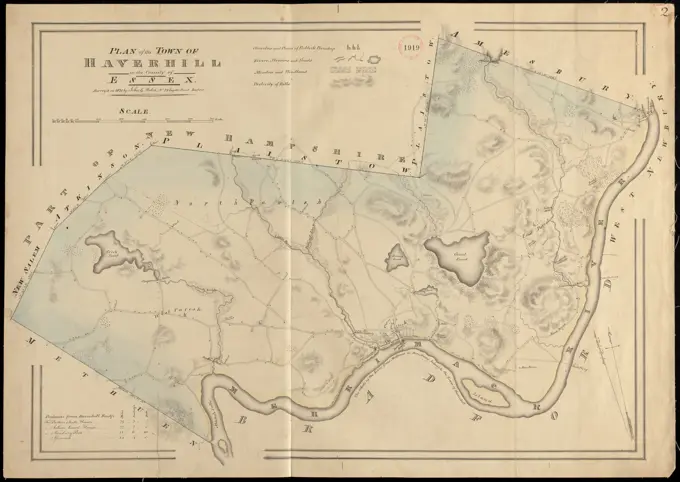
Nautical and Early MapsHistorical nautical charts and maps of coastal areas, depicting navigational routes, anchorages, and early cartographic detail from Massachusetts. Plan of Ipswich made by Philander Anderson, dated 1831 ,. Massachusetts. Office of the Secretary of State 295 assets in this story6145-505279286145-505682796145-513860826145-487189406145-559587916145-505113746145-542686626145-513949856145-505112316145-559148566145-513873106145-559151106145-592324006145-505197776145-542692866145-559164926145-505689846145-513964686145-505683046145-505344136145-487130906145-505572796145-505116346145-505676076145-487189336145-513935696145-487189956145-513892416145-559141086145-513919356145-559170986145-505690436145-487180906145-542676176145-484845426145-487190586145-551675846145-542679416145-505629516145-542677946145-505114106145-487128766145-542685714443-754675856145-551670144443-754777436145-513867906145-505112266145-505235366145-542694346145-542695346145-542677126145-442516846145-505112106145-513958256145-523743524409-175177446145-513924396145-559133416145-513945636145-523592166145-505675306239-708455576145-505675756145-559173416145-486244946145-290950466145-487195826145-542681876145-559134236145-487178546145-505696516145-559135426145-486244846145-559130836145-505575846145-559146526145-519298006145-486730516145-559563556145-290950696145-487180586145-487188816145-542690086145-513958336145-559154656145-505115636145-597146566145-505689814443-754771636145-559577696145-487129856145-559575936145-523593276145-505697066145-523593694443-754608356145-551670026145-559636296145-50534348 PREVIOUS of 3 NEXT